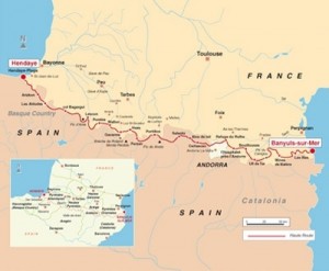
The HRP
The Haute Randonnée Pyrénéenne (HRP, sometimes known as the Pyrenean Haute Route) is a high-level route along the main ridge of the Pyrenees, from Hendaye on the Altantic Coast to Banyuls-sur-Mer on the Mediteranean coast. It’s roughly 800km long, and involves a total ascent of around 40,000m – 4.5 times the height of Everest.

The route was designed by Georges Véron in 1968 with the dual aims of taking the highest route and sticking near the border, unlike the GR10 (French) and GR11 (Spanish) which stay in their respective countries and aim to end each stage at a low level, generally near a village. By contrast, the HRP avoids civilisation for many days at a time, with overnight stops high up in the mountains.
In 1990 I walked Wainwright’s Coast-to-Coast with some school-friends. When we reached Robin Hood’s Bay, we began trying to think of another suitable challenge – we liked the idea of a long-distance A-to-B walkwith a sea at either end. Someone in the group came up with the idea of a coast-to-coast along the Pyrenees, and I was hooked on that idea for 20 years!
Just after my graduation in 1996 I set off with some friends from university to tackle a combination of the HRP and GR10. We were hit by various problems and ended up completing about half of the route, reaching Luchon. It was a fantastic experience, and ever since then I had wanted to go back and try again.
Unfortunately taking 2 months off work and away from their family wasn’t an option for any of my friends, so in June 2010 I set off solo. A couple of friends joined me for a few days near the end of section four (approaching Salardu), and I met some great people along the way, including Klaas, who I spent three weeks walking with.

