The Fear is Here
The guidebook I’m using gives each day a grade to indicate how hard it is. Grade 3 is a short easy walk, grade 2 is a “classic HRP day” with a fair amount of ascending and descending, and grade 1 is “suitable only for experienced, well-trained mountaineers.” The vast majority of days are grade 2, with a few of grades 1 and 3.

There is a fourth grade, E, which stands for extreme. There are 4 of these, and today was the first. I’d been looking forward to it, as it was the first day that involved serious snowfield crossings, but I’m no-longer looking forward to the others!
Given the length of the day, I dragged myself out of bed soon after 06:00 and set off about 7:45. My times were pretty good and I reached Col d’Arrious soon after 12:00, having climbed over 900m from the valley I’d crossed.
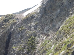
Shortly after the col there’s some via ferrata - a section of path up the side of a cliff, where they’ve put a cable for people to hold on to (see photo below) - called Passage d’Ortieg. I had a brief chat with an old French guy who looked troubled when I said I was about to do it. He warned me that there were icy sections, and I began feeling a pretty nervous as I approached it. Fear #1.
I stowed the walking poles I normally use and, once I’d got going, it wasn’t actually too bad. Most of the path was wide enough not to feel too precarious and I made a conscious effort not to look down!
I paused for lunch at the top of the Passage then headed down to Refuge d’Arrémoulit at 2,305m. I popped in to get some water and noticed the forecast was for storms this afternoon, so asked if it was still safe to carry on to Refuge de Larribet. The guardian replied that I should be quick, so I set off in a bit of a hurry - the last thing I wanted was to get caught in a storm while on snow at one of the highest cols I cross.

The climb to Col du Palas went pretty well, even though I could only see 2 or 3 other tracks. Once I hit the snow it took about 40 minutes on crampons to reach the top (2,517m), and although I’d swapped one pole for an ice-axe, it wasn’t really necessary.
After the col came the much talked about Port du Lavédan, which I heard on Saturday was unpassable last week. Getting there was a bit hairy, and I was glad I had the ice-axe this time. Again, there were only 2 or 3 tracks, but they looked pretty sensible so I followed them. I had to keep switching between crampons (for snow) and no crampons (for climbing boulder fields) then finished off with a big climb across a snowfield to arrive at the col (2,615m) on schedule.
As I’d been climbing up from Arrémoulit the cloud had been building high up, and fog had been moving up the valleys. The sun had disappeared for the final time, but visibility had been ok. As I crossed over Port du Lavédan though, that changed - visibility on the way down was about 10m.
The descent east looked remarkably steep, beginning with a nasty climb down a cliff. I couldn’t see any of the valley below but gradually picked my way down, rethinking my route several times when I found myself dangling off rocks I was uncomfortable with. Fear #2.
At the bottom of the cliff there was another massive snowfield. I refitted the crampons, grabbed the axe and set off down. Although I could barely see, things seemed to be going ok, but I thought I’d check my position with the GPS just to make sure I was heading the right way. I was a little surprised when the GPS coordinates were about 2km south of where I thought I was. Given that it was now after 16:00, I was on my own, I couldn’t see anything, a storm was expected, and only 2 or 3 people appeared to have done the route this year, I decided the best thing to do was get down and get off the snow, even if I was in the wrong valley. None of it made any sense though - I’d followed the map and (while I could still see) everything had fitted perfectly. I fired up the iPhone’s GPS and the map looked more sensible, but I was rather concerned as I headed down. Fear #3.

I checked the GPS after 5 minutes and it was still convinced I was 2km south of where I wanted to be, so I examined the map a bit more. I couldn’t see much of the valley due to the fog, but what I could see didn’t fit with the GPS coordinates at all.
I carried on down, crossed some more boulder fields, and came towards a lake. I checked the GPS again to see if it had come to it’s senses and it’s hard to overstate the relief I felt when I saw that the second number had switched from 47457 to 47477! It looks so simple on the screen, but those 2km had put me in the wrong valley, in the wrong country, with no path!
Once the GPS had sorted itself out most of my fears subsided. I had a few left though, involving a slip that needed a minor ice-axe-arrest, crossing a river that went under the snow and walking alongside a lake where I could see the snow had collapsed into the lake in places.
Eventually I made it to Larribet, about 90 minutes later than I’d hoped. After the day I’d had I wondered whether I deserved a bed, but since the thunder hadn’t arrived I thought I should probably camp. The refuge was empty when I popped in though, so I decided I’d have a meal there to keep the guardian company.
UPDATE: Since I got back to the UK, various friends have questioned my skills with a GPS and suggested that it was more likely to be my mistake than Garmin’s. Luckily the GPS was recording a log, and I now have evidence that the unit corrected itself at 15:39:55 (the GPS was in UK time, so it was actually 16:39 where I was) - either that, or I was suddenly propelled 3km at a speed of 537km/h. If you have Google Earth installed then this KMZ file shows where it all took place.

